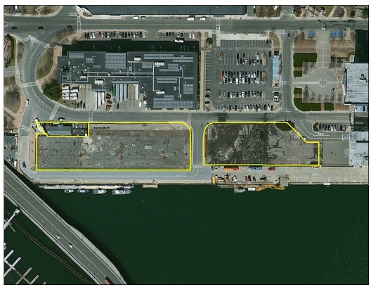
Parcels C-1 and C-2 are both located on Terminal Street within Boston Economic Development & Industrial Corporation (EDIC)’s 190-acre (77 ha) Raymond L. Flynn Marine Park in South Boston, adjacent to the Boston Inner Harbor. Together, the parcels make up 2.7 acres (1.1 ha) that are separated by an access road and offset from the waterside by a common use pier area managed by the EDIC. The two parcels are currently used as parking lots, containing 257 spaces. C-1 serves as parking for the Passenger Cruise Ship Terminal, and C-2, although designated for the Cruise Terminal, is currently used for BTD and BPDA/EDIC office vehicles. The pier area adjacent to the parcels are used by the Boston Marine Patrol, Boston Fire and Emergency Rescue, and several ferry operations. Use of the pier requires coordination with EDIC to coordinate berthing.
There are no overhead bridge restrictions for vessels navigating from this site to open water; however, the parcels are proximate to the Boston Logan International Airport (located across Boston Inner Harbor), which does impart height limitations on structures and operations in accordance with FAA regulations. Parcels C-1 and C-2 are approximately 132 nautical miles (244 km) from the leading edge of the offshore wind energy areas south of Martha’s Vineyard (likely transit around Cape Cod, due to vessel restrictions through the Cape Cod Canal).

Download the Parcels C-1 and C-2 Redevelopment and Reuse Assessment to view the potential redevelopment and reuse options at the site, including detailed cost information. Return to the main Ports Assessment page to read the full reports and visit the Massachusetts Offshore Wind Ports & Infrastructure Maps.
And download the Parcels C-1 and C-2 Existing Conditions Report to read the comprehensive assessment of the existing site conditions at Parcels C-1 and C-2.
As part of the existing conditions assessment, MassCEC has compiled a repository of existing documentation on Parcels C-1 and C-2, some of which is referred to in the Report. All site documentation is available below:
- Site photos
- Site plans
- Environmental reports
- RTNs – Release Tracking Numbers
- Site Licenses
- NOAA Charts